
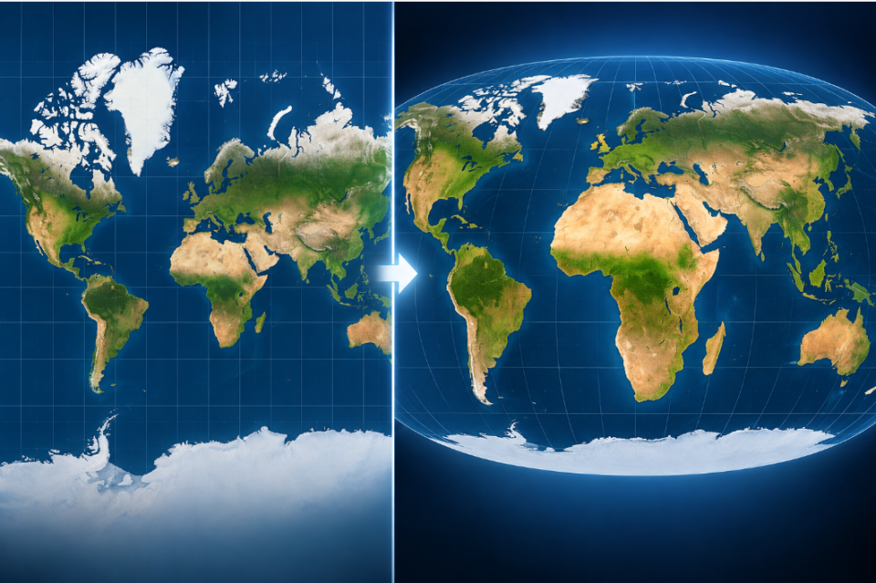
Africa’s true geographical scale is set to gain greater global recognition after the United Nations backed a new approach to world maps that more accurately represents continental sizes.
The United Nations General Assembly adopted the African-led “Correct the Map” resolution on 4 September 2026, encouraging governments, schools, technology companies and other institutions to use equal-area map projections that more accurately show the relative size of the world’s continents.
The resolution was adopted by an overwhelming 164 votes in favour, one against and six abstentions, marking a significant victory for an initiative led by Togo on behalf of the African Group. The United States was the only country to vote against the resolution.
At the centre of the initiative is a challenge to the centuries-old Mercator projection, which remains one of the world’s most recognisable maps but significantly distorts the relative sizes of landmasses.
Because the projection enlarges areas farther from the equator, regions including Europe, North America and Greenland appear disproportionately large, while Africa appears much smaller than its actual scale.
The UN resolution encourages the use of the Equal Earth projection and other equal-area projections, particularly in education and public communication where understanding the relative size of continents matters.
For Africa, the initiative is about more than correcting geography.
Supporters argue that maps influence how generations of people understand the world and Africa’s place within it. Changing the projection provides an opportunity to challenge a visual representation that has shaped perceptions of the continent for centuries.
Togo led the resolution on behalf of the African Group, with countries supporting the initiative describing it as an opportunity to improve geographical education and address historical distortions in the representation of Africa.
The Philippines said its vote represented support for correcting the historical cartographic distortion of the African continent and solidarity with Africa. Other countries stressed the educational value of representing continental landmasses more accurately.
The resolution does not change Africa’s physical size, international borders or territorial boundaries. Nor does it ban the Mercator projection, which continues to have applications where its particular properties are useful.
Instead, it promotes greater adoption of mapping approaches that preserve the relative areas of continents when maps are being used to communicate what the world actually looks like.
Several countries specifically emphasised that adoption of the resolution should have no impact on sovereignty, territorial integrity, internationally recognised borders or disputed territories.
The decision creates an opportunity for schools, governments, digital platforms and other institutions to reconsider the maps they use and how those maps influence perceptions of different regions.
For Africa, that means future generations could increasingly encounter a world map on which the continent occupies the geographical space it has always had — but has not always been shown to have.
The UN itself described the significance of the decision simply: the world is being encouraged to stop using maps that make Africa look smaller than it really is.
